
Announcing the 2026 U.S. Children’s Map Competition
Theme: Maps in Everyday Life
The 2026 U.S. Children’s Map Competition is now open.
This annual competition celebrates the creativity, imagination, and geographic curiosity of young mapmakers across the United States.
The international Barbara Petchenik Children’s World Map Drawing Competition is held every two years. The 2026 U.S. competition is a national-only year, so entries will not automatically advance to the international level. However, selected entries may be eligible for consideration in the next international competition cycle.
Deadline
Entries must be received on or before March 12, 2026.
Exhibition
All submitted entries will be exhibited at the Association of American Geographers Annual Conference in San Francisco, March 17 through March 21, 2026, providing national exposure to the geography and cartography community.
Eligibility
The competition is open to all children 15 years old or younger as of January 1, 2026.
Age categories:
- Under 6
- Ages 6–8
- Ages 9–12
- Ages 13–15
Entries may be created by:
- A single child
- Up to three children working together within the same age category
This Year’s Theme: Maps in Everyday Life
Students are invited to explore how maps shape, guide, and reflect daily life.
Maps may be illustrated using drawings, pictures, words, or other graphic elements. Each entry must include a recognizable map of the world, showing all or a large portion of the world, with identifiable continents and age-appropriate features.
Maps should tell a story or convey a message about the world, whether as it is today, tomorrow, or in the future.
Rules and Judging Criteria
Although 2026 is a national-only year, entries will be evaluated using the same core standards applied in the international competition.
Judging focuses on three primary criteria:
- A recognizable message
- Cartographic content
- Quality of execution
What Judges Look For
1. Clear Connection to the Theme
A recognizable connection between the form, shape, and use of cartographic elements that creatively addresses this year’s theme, Maps in Everyday Life.
2. Recognizable Representation of the World
A recognizable image of all or a portion of the world in which:
- The shapes and relative locations of land masses and oceans are as accurate as reasonably expected for the child’s age
- The representation is appropriate within the context of the projection or visual system used
3. Effective Use of Cartographic Elements (Ages 13–15)
In the oldest age category, judges also consider the thoughtful use of cartographic elements such as:
- Symbols, colors, names, and labels that support the theme
- Clarity and legibility of point, line, and area symbols
- Appropriate use of materials, whether drawn or constructed
- Expressive and effective use of color, including:
- Changes in value to show quantitative differences
- Changes in hue to show qualitative differences
- Overall aesthetic quality, including balance and harmony among image elements
Entry Requirements and Parameters
To ensure entries can be properly exhibited and photographed, please follow these guidelines:
- Maximum size: A3 (420 mm x 297 mm or 17 x 11 inches)
- The surface must be flat. Pasted-on objects may not exceed 5 mm (0.2 inch) in height and must be securely attached
- The map may be made using any unbreakable material. Glass is not permitted
- No movable or fold-out parts that cover sections of the drawing. The complete work must be visible in a single photograph or scan
- No perishable or unstable materials such as plant leaves
- Do not plasticize or laminate the drawings, as this alters the physical appearance
Original Work Requirement
- The entry must be an original piece of work created by the child or children
- Traditional methods should be used, such as colored pencils, watercolor, or similar media
How to Submit
Please complete all steps below:
- Complete the online submission form (one form per student).
- Download and complete the required entry form (PDF).
- Print the entry form and attach it to the back of the artwork.
- Mail the physical artwork so it is received on or before March 12, 2026.
Mail entries to:
Colleen Conner
Esri Library
380 New York Street
Redlands, CA 92373
Contact
For questions or additional information, please contact:
Colleen Conner
cconner@esri.com
U.S. National Coordinator
Jim Thatcher
jim.thatcher@oregonstate.edu
Celebrating the Winners of the 2025 U.S. Children’s Map Competition!
We are delighted to share the results of the 2025 U.S. Children’s Map Competition! This annual contest celebrates the imagination, geographic curiosity, and artistic talent of young mapmakers from across the nation. We extend our congratulations to all participants and especially to this year’s outstanding winners:
Under 6 Years Old
First Place: Rithvik V. (5), Monmouth Junction, NJ* (Rithvik’s map went on took place 3rd internationally in the Under 6 category at the 2025 Barbara Petchenik Children’s World Map Drawing Competition!)
Second Place: Jenna R. (4), Søborg, Denmark
Ages 6–8
First Place: Francis L. (6) & Patrick L. (8), Murphy, TX*
Second Place: Anica H. (8), Duluth, GA
Third Place: Zoe J. (7) & Cora A. (8), Redlands, CA
Ages 9–12
First Place: Jane A. (9) & Davis K. (9), Redlands, CA*
Second Place: Amalia C. (11), Jacksonville, FL
Third Place: Lin H. (10), Duluth, GA
Ages 13–15
First Place: Claire B. (14) & Lily C. (14), Bozeman, MT*
Second Place: Gillian S. (15), Bozeman, MT*
Third Place: Kanghyeon B. (15), Meridian, ID*
*Top 6 selection
Special Awards were also presented to several remarkable entries that demonstrated exceptional creativity, technical skill, or thematic depth.
The top six entries (marked with an asterisk) represented the United States in the 2025 Barbara Petchenik Children’s World Map Drawing Competition. Their artwork was featured at the International Cartographic Conference (ICC), held July 28 – August 1, 2025.
We are especially proud to share that Rithvik V. earned 3rd place at the international level in the Under 6 category, a tremendous achievement on the world stage.
Thank you to all the students, educators, and families who helped bring this year’s competition to life. We are continually inspired by the vision and talent of the next generation of mapmakers.
Note: Information on the 2026 U.S. Children’s Map Competition will be shared on this site in November 2025.
Explore Past Entries and Winners
Archives of previously submitted maps in the Petchenik Children’s Map Competition:
Books of maps from the Petchenik Children’s Map Competition:
- The World Drawn by Children (2021)
- Children Map the World (2015)
- Children Map the World (2005)
More Information
For more info on the international competition, please visit the website of the International Cartographic Association, the Commission on Cartography and Children, or the Commission’s Facebook profile. Check out the winning illustrations from previous competitions on the website of the International Cartographic Association. You can search and browse all maps entered in the competitions since 1993 in the Carleton University Library archive of the Barbara Petchenik Children’s Map Competition.
About Barbara Bartz Petchenik
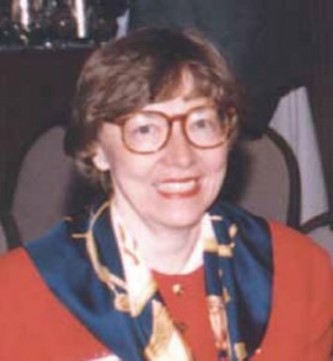
Dr. Barbara Bartz Petchenik is among a number of pioneering women who contributed significantly to modern cartography across the globe. She is remembered predominantly for her interest and research into the theme of children’s maps and atlases. But this is by no means the only area that she specialized in. From 1962–1992, she contributed to about 60 articles, papers, reviews, and other map related research in cartographic typography and type legibility, communication aspects, historical cartography, and the psychological aspects of map design, among others. During her career as a cartographer, Barbara Bartz Petchenik believed in the power of maps to communicate a “larger, meaningful, reality.”
She grew up in a rural town in northern Wisconsin. She got her Bachelor of Science degree from University of Wisconsin–Milwaukee in chemistry and English, and she taught geography there the year after she graduated. She then went to University of Wisconsin–Madison for graduate work. She intended to focus on physical geography but soon discovered cartography, and thus began her illustrious and prolific career in cartographic research and writing through collaborations with her mentor and friend Arthur Robinson. Together they established foundations for American cartography as we know it today.
Before obtaining her PhD, she was the cartographic editor with the Field Enterprises Education Corporation in Chicago where she was a cartographic researcher and designer for the World Book Encyclopedia. She is well known for research on children’s cognitive abilities with maps which began in earnest in the early 1960s through her work on the World Book Encyclopedia. Her research focused on maps designed for nine through fourteen-year-old children. She interviewed a thousand elementary school students and observed how they interpreted symbology, scale, coordinates, typography, and other map content. Their distinct perspectives differed from those of adults, and lessons on clarity and simplicity in cartographic design shaped her philosophy on cartography and map design in general. She used the word “miraculous” to describe children’s abilities to find meaning on maps in a unique way.
After earning her doctorate in 1969, she returned to World Book as a Staff consultant in Cartographic Research and Design. She worked at the Newberry Library in Chicago where she was co-author and cartographic editor of the The Atlas of Early American History. She later coauthored a scholarly, philosophical book, The Nature of Maps (1976), with Arthur Robinson. This is perhaps her most significant publication. Robinson and she also co-wrote two works about communications aspects of cartography, including the award-winning “The Map as a Communication System”. She became the senior sales representative of cartographic services for the R.R. Donnelly & Sons Company, a commercial map-making organization, as a sales representative to consult with clients on planning, designing and producing maps for publications, textbooks. She managed to write more than sixty articles, reviews and essays on cartography, about the theory and practice of map design and cognitive aspects of the discipline. Through all of this, she became a true trailblazer for women in cartography.
Barbara was involved in many cartographic associations and was a member of the US National Committee for the ICA. In 1991, she was the first woman to be elected to the ICA Executive Committee of the International Cartographic Association. She served as a vice president until her death after a short illness in June 1992. At that time, the U.S. appointed Judy Olson to the ICA EC to complete Barbara’s term (until 1995). In 1993, the biennial Barbara Petchenik Children’s World Map Drawing Competition was created by the ICA as a memorial of Barbara’s lifelong interest in maps for children. The aims of contest named in her honor are to promote children’s creative representation of the world, to enhance their cartographic awareness and to make them more conscious of their environment.
Sources
- Bevington-Attardi, Dierdre. 2021. Personal communication.
- Tyner, Judith. 2019. Women in American Cartography: An Invisible Social History. United States: Lexington Books.
- The Future Mapping Company. Women who shaped the world: Barbara Petchenik.