CaGIS is pleased to announce the winner of the Best in Show and of the Professional Interactive/Digital Map Category in the 53rd Annual CaGIS Map Design Competition:
Winner, Professional Map Competition (Interactive/Digital)
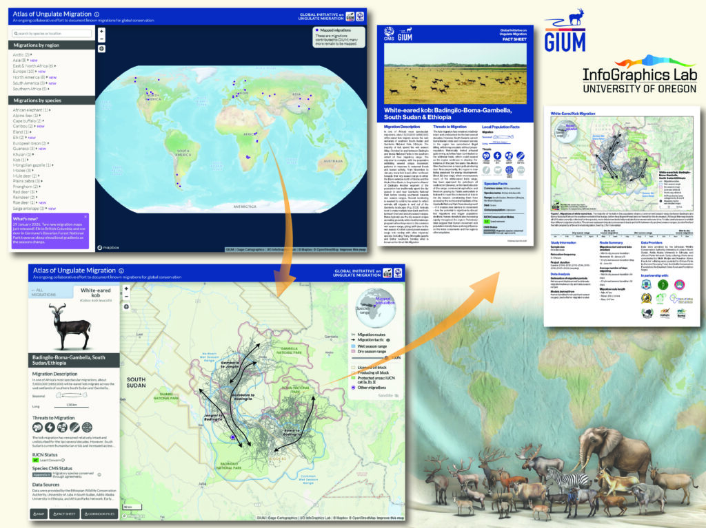
The Atlas of Ungulate Migration
By Kauffman, M., S. Albeke, M. Atallah, M. Boyers, F. Cagnacci, S. Chamaille-Jammes, J. Fugate, I. Freeman, J. Gage, M. Hebblewhite, G. Hopcraft, W. Kirkpatrick, J. Merkle, J. Merson, T. Mueller, S. Mumme, A. Mysterud, C. Nobbe, W. Peters, E. Steiner, A. Steingisser, editors. (Bavarian State Institute of Forestry; Centre National de la Recherche Scientifique; Fondazione Edmund Mach; Gage Cartographics; Senckenberg Nature Research Society; University of Glasgow; University of Oregon, InfoGraphics Lab; University of Wyoming, Wyoming Migration Initiative)
Click the links below for a list of winners and image gallery:
Congratulations to all of the winners and honorable mentions and thank you to everyone who entered the competition!
About the Competition
The purpose of the CaGIS Map Design competition is to promote interest in map design and to recognize significant design advances in cartography. The focus of this competition is design; therefore, judging is based on cartographic design criteria, such as creativity, text (spelling and grammar, too), balance, unity, visual hierarchy, clarity, use of color, and subject matter.
About the Student Competition
Each student award consists of a cash prize ($500) and a copy of Avenza MAPublisher. Student mapmakers in a certificate, diploma, or degree program (bachelor, masters, doctorate) must have produced their entries with student facilities as part of an accredited course. Student entries must be verified via the instructor. Winning entries will be displayed at a number of national and international professional functions and digital images of winning entries will be provided (with permission) to educators and teachers as examples of excellent map design for their students.
Best of Show, Winning entries (in each category), and Honorable Mention entries (in each category) of printed maps will then become part of the permanent collection of the U.S. Library of Congress. Note that the Library of Congress is unable to accept digital maps at this time. Maps provided to the Library of Congress will be made available to patrons and researchers for on-site access and fair use copies. Treatment of all maps received from the Competition will comply with U.S. Copyright law.
There are NO FEES for student entries.
Student Categories:
- Arthur Robinson Award for Best Printed Map: A map or map series designed specifically for print or static media.
- David Woodward Award for Best Digital Map: A map or series of related maps designed specifically for digital media (i.e., interactive and/or animated for the Web or a mobile app).
About the Professional Competition
Professional Categories:
- Reference: A map whose objective is to show the location of a variety of different features. The focus of a reference map is on accurate depiction at a given scale of the location of individual environmental features.
- Thematic: A map whose objective is to illustrate a theme or the relationship among several themes. The focus of a thematic map is on the structure of the distribution rather than on location.
- Interactive/Digital: Interactive or animated maps or Story Maps that are made for the web, or as plug-ins to Windows and MAC computers, or as mobile apps.
- Book / Atlas: Atlases and books use original maps as the primary (in the case of an atlas) or a significant (in the case of a book) communication device.
- Recreation / Travel: A map designed to assist readers in pursuit of recreation or travel, such as road maps, trail maps, and maps of parks or natural areas.
- Other: This category is for submissions that do not fit into any other category. Judges reserve the right to assign entries to another category if they feel it is appropriate and will offer an award only for an exceptional map that does not correspond with the other categories.
There are NO FEES for professional entries.
How to Enter
Submit your entry by January 31, 2026. (All submissions must be received by this date.)
Please complete and print the form from below or attached. Include the completed form with one, full-size, print copy of your map or map product and mail to the CaGIS Executive Director at the address below. Note that unless you are submitting an entry for the digital/interactive category, you must send a copy of the printed map to be entered into the competition.
Note that winning entries will be displayed on the CaGIS website unless otherwise instructed.
Submission Directions
In addition to the mailed print copy of your map, please email a digital copy of your map (for interactive digital maps, please include a link to your map as well as a representative screen capture) and the completed entry form to the following email address: cagisexecdir@gmail.com.
Mail the print copy of your map or map product to CaGIS Map Competition c/o Kari Craun at the address below:
CaGIS Map Competition
c/o Kari Craun
15316 County Road 5190
Rolla, MO  65401