The Preliminary Program for the 2024 CaGIS+UCGIS Symposium is now available. Information about plenary speakers is also available. Register now to reserve your space at this important event!
2023 MAP DESIGN COMPETITION WINNERS ANNOUNCED
CaGIS is proud to present the winners of the 2023 Map Design Competition. We thank the many contributors and judges! Please be sure to visit the 2023 Gallery to see some of the winners from this year’s competition.
STUDENT SCHOLARSHIP ANNOUNCEMENT
The Cartography and Geographic Information Society (CaGIS) proudly announces that applications are now being accepted for the Society’s annual scholarship awards. The scholarships recognize academic achievement and encourage the continuing success of outstanding cartography and geographic information science students. The scholarships also recognize achievement or potential for achievement in original research advancing the specific disciplines of cartography or geographic information science. CaGIS will award two Master’s Scholarship Awards ($1,000 each) and two Doctoral Scholarship Awards ($1,500 each) to outstanding applicants.
Applications are due by March 31, 2024, and can be submitted in the online application form (https://forms.gle/WwvhqX4Fp9fkHvc86). Award recipients will be announced in May, 2024. Please see the CaGIS Student Scholarships page (https://cartogis.org/awards/students/) for more information.
Call for Nominations – CaGIS Board
The CaGIS board is currently seeking nominees for future board positions. Currently, we are seeking nominations for Vice President and two members of the Board of Directors. The elected Vice President will serve a four-year term as VP, President-Elect, President, and Past President. The Directors will each serve a four-year term.
CaGIS rotates the officer positions among 1) government or private sectors and 2) academic sector, the next VP nominee will be selected from government or the private sector. The terms for those elected this year will run from spring 2024 until spring 2028.
These positions include participating in one face-to-face Board meeting per year as well as one virtual Board meeting. The face-to-face meeting is typically in conjunction with other meetings CaGIS members attend (such as the Annual AAG Meeting or CaGIS Conference) with travel reimbursement provided. Other time required will depend on which CaGIS activities you choose to be more involved in as an officer or director.
By choosing to serve as an officer or a board member, you will have the opportunity to influence the direction of the Society while working with a fabulous group of people. You will be able to have direct input on the priorities of the society, future conference planning, and membership and financial strategies while expanding your professional network of amazing cartographic and geospatial contacts.
The next two years are extremely important for CaGIS. We will be co-hosting the 2024 CaGIS + UCGIS Symposium in Columbus, Ohio from June 3-6 and will be providing support for the International Cartographic Conference in Vancouver, British Columbia July 28-August 1, 2025. In addition to conference support, CaGIS provides the community with a peer-reviewed journal, a number of student scholarships, an annual Map Design Competition, and serves as the United States liaison to the International Cartographic Association. As an officer or a board member, you will have the opportunity to participate and influence all of these activities.
So, if you would like the opportunity to make a significant contribution to CaGIS and the geospatial community as a whole (or if you would like to nominate someone whom you think could make a significant contribution), please contact me via e-mail at coled@si.edu by November 15, 2024. The election of CaGIS officers will take place in December 2024. The first face-to-face CaGIS Board meeting after elections will be in conjunction with the 2024 meeting in Columbus in early June.
Dan Cole, CaGIS Past President
Call for Participation: 2024 CaGIS + UCGIS Symposium
Announcing the Call for Participation for the 2024 CaGIS + UCGIS Symposium to be held June 3-6 in Columbus, Ohio. The theme of the conference is Climate Smart GIScience: Mapping a Sustainable Future. Submission of research paper abstracts, vision statements, poster/lightning talk abstracts and workshop proposals are welcome.
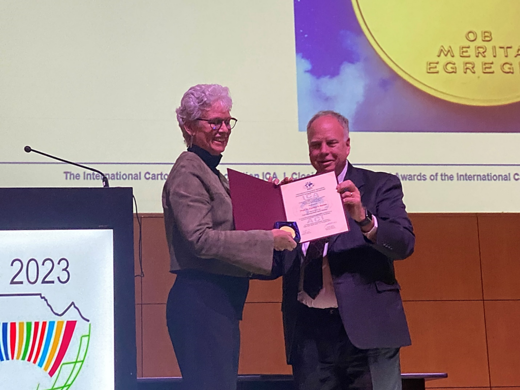
Dr. Cynthia (Cindy) Brewer Receives ICA Carl Mannerfelt Gold Medal
Dr. Cynthia Brewer received the ICA Carl Mannerfelt Gold Medal during the Awards Ceremony at ICC 2023 in Cape Town, South Africa. The nomination was submitted by Aileen Buckley, U.S. Primary Delegate to the ICA and Chair of the U.S. National Committee for the ICA and Anthony Robinson, The Pennsylvania State University. Some of Dr. Brewer’s notable achievements are described in her nomination document,
“Dr. Brewer is widely known for her contributions to color theory in cartography, with the most impactful of her accomplishments being ColorBrewer, a web application that has helped innumerable people worldwide make appropriate and perceptually viable color choices for thematic maps. These color schemes are found today in commercial and open-source software packages used by tens of millions of people every day. Few others in our field can make any such claim to broad, daily impact on so many around the world. Her impact on the field of cartography has cemented her reputation as the world’s foremost expert on color in cartography, earning international acclaim. Dr. Brewer’s work does not stop with color, however, as she has led other significant projects all aimed at helping people to make better maps. These additional works include, among others, ScaleMaster, a tool developed though collaboration to provide guidance on generalization and multiple representations of geographic data. Her work has influenced the field to such an extent that the notion of creating a Brewer has become a goal for other academic Cartographers…”
Dr. E. Lynn Usery Receives ICA Honorary Fellowship Posthumously
During the International Cartographic Conference in Cape Town, South Africa, Dr. E. Lynn Usery was awarded the ICA Honorary Fellowship. An excerpt from the nomination document summarizes Lynn’s contributions to the fields of cartography and GIScience:
“Because of the breadth and depth of his involvement and contributions, the extraordinary impact that Dr. E. Lynn Usery has had on the fields of cartography and GIScience cannot be overstated. Not only was he a cartographer and GIScientist of international reputation, but he also made many extraordinary contributions to the ICA. For this reason, it is fitting that he be awarded the ICA Honorary Fellowship posthumously.”
Save the Date: CaGIS Conference 2024 (June 3 – 6)
CaGIS is joining the University Consortium for Geographic Information Science June 3-6 in Columbus, Ohio for our 2024 CaGIS Conference. The theme will be related to understanding climate change and sustainability through Cartography, GIScience and GeoAI. Watch for the Call for Abstracts, coming soon!
CAGIS Presents the 2023 Distinguished Career Award to Barbara Buttenfield

University of Colorado
Dr. Barbara (Babs) Buttenfield was awarded the CaGIS Distinguished Career Award. We congratulate Babs on this very well-deserved recognition of her amazing career and significant contributions to the cartography and GIScience disciplines.
CaGIS Rising Grant Awarded
A CaGIS Rising Grant was awarded to the project, “Characterizing and Promoting Cartography and GIS Graduate Programs through Research Theme Discovery and Online Seminars.” Students involved in the project are: Yuhao Kang, Yanbing Chen, Bing Zhou, and Zhining Gu. Advisors are Song Gao, Lei Zou, and Wenwen Li.
CaGIS Rising projects include research or outreach efforts that have the potential to transform global challenges into new opportunities that advance and promote Cartography and GIScience. Creativity, novelty, and the potential for broader impacts to society constitute key criteria for evaluating these proposals for funding.